Thanks! It probably can be cropped from left but I prefer to include at least some of village for context, otherwise it's hard to understand what's under clouds. And this snow with tracks in foreground does not hint of distant wilderness, if it were pure snow then i'd probably tried to eliminate all non-natural elements.
Jan. 2, 2026
38
-

-
I like this shot, but maybe it would been better if the path leading to bridge and/or going from bridge is visible, right now the bridge looks like isolated artifact.
-
These shots look more like spring shots with lack of snow on southward slopes and "grainy" snow. Alas, that's the times we live on.
-
Gritty and BW seems to work well for industry shots, especially old industry.
-
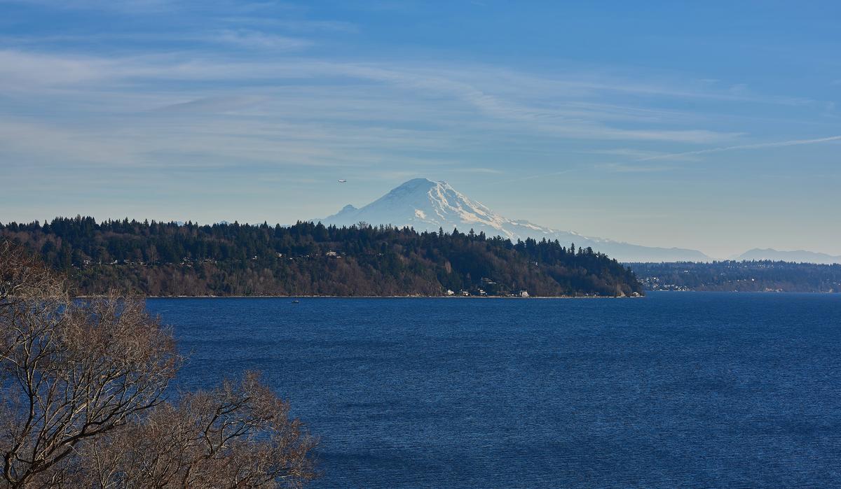
Great neighborhood to have and what a view. But this shot seems to be bit unbalanced due to all the interesting elements being on top half of image and lower half mostly empty with sea. Maybe cropping half of sea off would work better?
-

Thanks for the input. I agree and will give it a try. Cropping is a very strategic tool. Many, many times I have gone back months later... and cropped an image for better results!
-
-
Indeed snow is a bit thin...what altitude ?
-
Gritty B&W works
-
Managed a week skiing in the French Savoie. Snow pretty limited below 1800m but above it's still hanging around. Damn cold as well...
 010126 Albiez moon La Toussuire by softmarmotte, on Flickr
 010126 Albiez emy contamines by softmarmotte, on Flickr
 010126 Albiez le jeune by softmarmotte, on Flickr
 010126 Albiez view to la toussuire by softmarmotte, on Flickr
 010126 Albiez les aiguilles by softmarmotte, on Flickr
 010126 Albiez misty evening by softmarmotte, on Flickr
 -

In the second photo here, we were walking at just over 1500m in the snow. The Höchkönig mountain range that you can see in the first goes up to 2900m
-
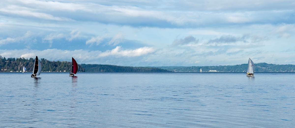
I like this shot the bright light blue colours are great, the clouds and the boats are interesting elements in the image.
As to the composition, it looks OK to me. Maybe you could try experimenting with a crop of some from the left so that the first boat with white sail, that is a bit close to the edge, is removed ?
... that seems to simplify the image for me a bit, and then there are only 3 boats left, and apparently 3 is a good number 😉 -
I like both of these,
In the first, that tree behnds the "bus stop shelter" looks huge!!
and the yellow leaves on the right look a bit like a firework exploding 😀In the second, it looks like you can cross the bridge and enter world with a sea of floating yellow leaves.
But maybe I'm just imagining these thes things 😁 -
There is still a chance to do something about global warming, and all its unwanted side effects, before the world becomes intolerable.
A lot of good progress towards renewable energy sources has been made already, but the empire is fighting back. So more efforts are needed.
Already Austria, where I live, and the UK , where I come from, both have growing shares of their total energy coming from renewables. That share is already about 45% of the total! (electricity, heating, transport, industry ,...) -
Some very good shots here, especially these two I selected.
In your second shot you've chopped off the peak of the mountain which I don't like, but the rest of the shot is good.
In the first shot here the colours are intriguing with the typical mountain blues contrasted to the much warmer yellowish colour of the moon. Warmer colours seem to pull an object closer to the viewer, so I think this helps the moon to look bigger in the shot?
The contrast of the dark blue rocks and the bright snow in the mountains looks good, and the "out of focus" branches give a slightly spooky feel to the imageThe last image concentrates on that sea of fog below in the valley. We don't need to see what it's covering up, that's all part of the mystery created in this shot.
The gentle sunset colours in the sky and those high contrast mountains look great -
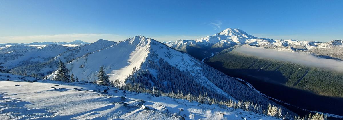
The IQ is simply superb on #2. Very good! #3 as well. It seems you are very deft with your PP process... able to extract the maximum from the source. Or, is the Lumix 70-300 THAT good? Or probably a combination of the two plus a good sensor. Nice. Time of day (light) is perfect, too. My only good-natured niggle (since I am a pano guy)... is... I would have taken one more frame (to get the top of the peak) and then stitched the two together! LOL. Well done as-is! :-) We are finally getting some snow in the Cascades, so I hope to get up to the mountains this month. Or even next month. Our winter/ski season usually extends into mid/late March. When we have really big snow years (few and far between these days) the ski areas will close per the usual schedule (March/April). But in those instances when it is a big snow year, there is a tradition that they will open-up for one day on the Fourth of July. Ski in your shorts with no shirt! But just the highest elevation ski area (base @ 3912 ft / 1192m; summit @ 7012 ft / 2137m). Fun! Here's a pic from last winter (cell phone)... looking west from the Summit House with Powder Bowl in the foreground, the Silver King just to the left, Mt. Rainier in the distance (right), and Mt St. Helens in the far distance (left). Powder Bowl is challenging (the chairlift, C6 Campbell Basin, is on the "back side" -- you can't see it from this vantage point). Many years ago (1990's) we would hike into the south backcountry and ski the face of Silver King (both powder and ice conditions). At my age now... I probably wouldn't dare do it. Especially ice.
-
Agree... and I gave it a try! I think it is an improvement, but it was really kind of a "nothing" pic to begin with. Mainly an exercise... to properly expose a series of frames, hold the camera steady (no stabilization in the lens or the sensor) and then stitch things together and see what you get. Composition? LOL. :-)
-

Were you around when Mt St. Helens blew its top? Would have been quite visible from that location. I have always been fascinated by that eruption.
-
Yes. I have a story. I climbed Mt. St. Helens in 1979 (when it was almost a perfect "cone" -- that's a separate story, LOL). Mt. St. Helens erupted on May 18th, 1980 (a Sunday). Earlier in the spring of that year (March/April 1980) I was sailing on a regular basis every week (Commencement Bay in Tacoma). We could see the steam/smoke plumes rising into the atmosphere as we tacked back-and-forth east/west/east/west. A front row seat to take-in the action! But those early precursors were only in the range of 10,000 to 15,000 feet high (3000m to 4500m). Then, I was in Ellensburg (middle/eastern part of the State) the weekend it erupted - visiting friends. I had a motorcycle at the time, so it was a nice springtime ride from Seattle to Ellensburg (Friday afternoon/evening). On Saturday, we rafted the Yakima River and then stayed up late having fun that night. There were about 8 of us sleeping on the floor of a college dorm room. On Sunday morning, around 8:30 AM, I woke up. Kind of. For some reason. "Something" woke me up. It was probably the eruption (5.1 on the Richter scale). Maybe I felt a gentle ground vibration? But I was 100 miles away (160 km) as the bird flies. And I don't recall people saying that they "heard" anything. So I must have felt something. Anyway, I looked around the room at 8:30... and everyone else was still asleep, snoring. Makes sense. We had been up LATE drinking beer after a long day of river rafting. The window curtains were closed, but I could definitely "see" that it was "light" outside. I laid there awake. Time passed by. 15 minutes. 30 minutes. Then I started to notice that the light outside was "changing" and by 10:00 AM it was TOTALLY DARK outside with a dense "fog" (ash). Holy smokes! The eruption plume was traveling eastward... and had blocked out the rising sun. It was totally dark. By that time, everyone was awake and we pretty-much knew what had happened. And... we knew that NOTHING was going to happen on Monday... so... we went to the bar and brought back several growlers... and had another party! LOL. :-)
From Google...
The Mount St. Helens ash cloud covered eastern Washington, causing total darkness in cities like Spokane, within just a couple of hours of the May 18, 1980 eruption, as winds carried the ash eastward at speeds of about 60 mph, with the ash eventually spreading across the U.S. in three days and circling the globe in 15 days. After the lateral blast, the ash column rose rapidly, reaching over 12 miles (20 km) high within 10 minutes and approximately 80,000 feet (24 km or 15 miles) in less than 15 minutes.
-
-
Thanks Trevor...yes the top of the mountain annoyed me too. My paws were so cold at this point I just took the one shot instead of vertical pano. Thought I'd post it anyway as I liked the rest...just a bit annoying. The evening colours for the mist were great but I did have to run up the mountain to catch it in time. I took quite a few of the moon in the days around this but this one stood out - it's actually from our living room window