• Members 568 posts
    Oct. 22, 2023, 4:30 p.m.

    Cloud Capp'd Towers

    PA210246.jpg

    PA210244.jpg

    PA210233.jpg

    PA160054.jpg

    The cloud-capp'd towers, the gorgeous palaces,
    The solemn temples, the great globe itself,
    Yea, all which it inherit, shall dissolve,
    And, like this insubstantial pageant faded,
    Leave not a rack behind: We are such stuff
    As dreams are made on, and our little life
    Is rounded with a sleep.

    Prospero, The Tempest

    PA210244.jpg

    JPG, 2.0 MB, uploaded by Woodsider79 on Oct. 22, 2023.

    PA210246.jpg

    JPG, 1.7 MB, uploaded by Woodsider79 on Oct. 22, 2023.

    PA210233.jpg

    JPG, 2.1 MB, uploaded by Woodsider79 on Oct. 22, 2023.

    PA160054.jpg

    JPG, 2.2 MB, uploaded by Woodsider79 on Oct. 22, 2023.

  • Members 796 posts
    Oct. 22, 2023, 5:14 p.m.

    Wow, these are great, especially the first

  • Members 1457 posts
    Oct. 22, 2023, 5:52 p.m.

    Sometimes "bad weather", makes for impressive pictures, like these.

  • Members 269 posts
    Oct. 22, 2023, 6:14 p.m.

    Back To Borrowdale

    On Saturday I returned to Borrowdale to take another look around Cummacatta Wood and hopefully complete the route I'd planned the previous week by heading up to the summit of Kings How.

    To this end, I'd planned not to get distracted in the woods and make my way directly to the steep path leading up to the fell. Of course, two hours after setting out I'd wandered off the main path into the woods and only got about half a mile away from the car park. Best laid plans and all that.

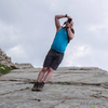
    Eventually I did make it to the path leading up to Kings How and very slowly made my way up there. The stone steps were steep, wet and very slippy, so I ended up using my tripod as a makeshift walking stick for most of the ascent. I didn't fancy my chances coming back down that way and picked a route back off the other side of the fell instead, which turned out to be rather enjoyable, albeit still a bit ropey.

    In total, despite attempting to be a bit more picky and less wasteful, I shot 270 images (that figure includes some bracket shots), which I pared down to roughly 50 that I quite liked, mostly woodland images, although the 16 I've selected here are a bit more varied. I suspect I'm going to be populating the extra two slots on my NAS sooner than I'd originally expected.

    All images were taken with the GFX100S and 32-64, mounted on a tripod and mostly using a CPL. Processed from individual raw files in Capture One Pro 23. I did take some shots early on with the 100-200, but these seem to have been rejected at the early picking stage and as the walk progressed I got less and less enthusiastic about swapping lenses, so it stayed in the bag for most of the time, even though there were quite a few times when I could have done with something a little bit longer, like the 45-100 (35-80 ish), which I wonder if it would be more suitable as a general purpose lens than the 32-64? If I ever lay my hands on one I'll let you know.

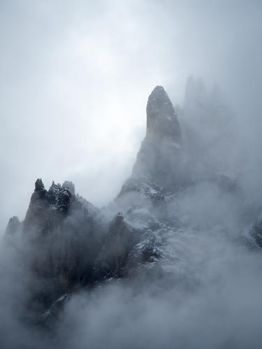
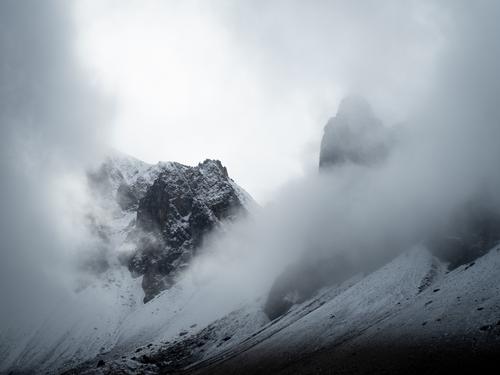
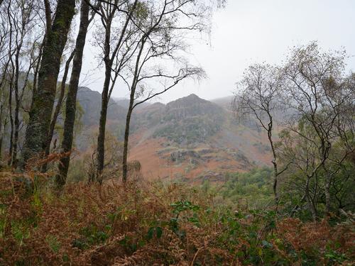
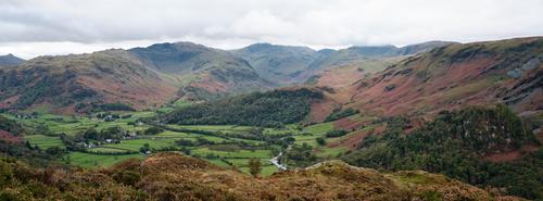
    1. Nitting Haws In The Mist

    As I prepared to set out from the car, a short lived bit of mist rolled in, partially obscuring the far side of the valley. I managed to take this shot before it disappeared again.
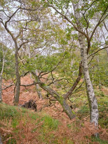
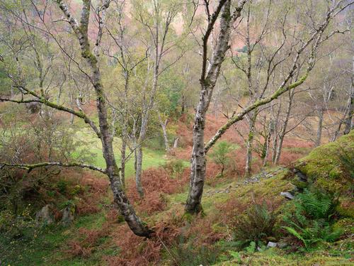
    DSCF4552.jpg

    2. Support

    A short way from the car park, I decided to leave the main path and have a poke about in the woodland to the West. This turned out to be a great place, with lots interesting trees in various scenarios. This one was a little different. Looking like the tree in the middle while falling over has grabbed its neighbour for support.
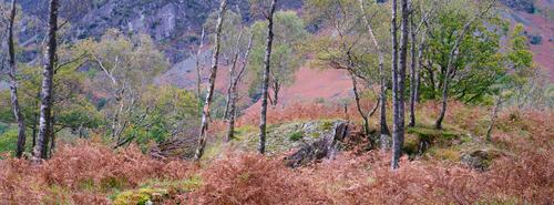
    DSCF4581.jpg

    3. Autumn Is Here

    This shot is on the edge of the woods. The backdrop is the far side of the valley, providing an attractively contrastingly coloured background. I framed it for 65:24 in camera. I took a 16:9 framed shot too that omits the Birches on the left but includes more of the full height of the trees to the right.
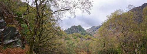
    DSCF4610.jpg

    4. Castle Crag

    I shot this scene, or something very like it last week, but that was after the sun had set and I wanted to see how it looked in daylight. Unfortunately, the light is nothing special. A bit of direct light on Castle Crag wouldn't have gone a miss.

    DSCF4623.jpg

    5. Split Ends

    Here I'd scrambled up a moss covered slag heap to try and get a different perspective on a small enclosed mining area. On my way back down to safety I spotted this scene. I think my tripod was perched on a couple of protruding rocks and my feet were in constant danger of slipping from under me when I took this.
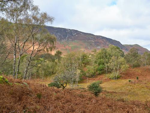
    DSCF4632.jpg

    6. Catbells

    Back on the safety of the main path and there was a fleeting burst of nice light on the woods in front of me. Catbells is the pointy hill on the far right. It's one of the more accessible fells in The Lake District and if you're feeling adventurous having reached its summit, you can carry on along the ridge over Maiden Moor and High Spy to reach Dale Head, an excellent walk. Although, don't be tempted to descend part way along the ridge via Nitting Haws. Speaking of which...

    DSCF4648.jpg

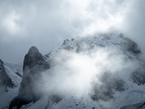
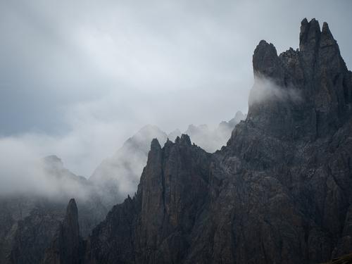
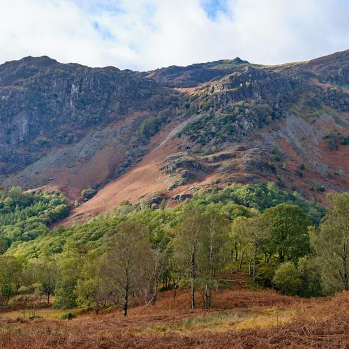
    7. Nitting Haws In All It's Terrifying Glory

    Nitting Haws is the rocky outcrop roughly on the upper right 3rd of this image. When I first started exploring The Lake District, one of the earliest walks I planned was from Grange to High Spy (the pointy bit right at the top) and I plotted a route following the path on the OS map that ran through Nitting Haws. The problem is, there is no discernible path running through Nitting Haws, what there is, is serious risk of sudden death as you plummet into the gorge that runs alongside it. On this particular occasion, I managed to carefully pick my way past the gorge and made it to the top, only to discover it was all covered in deep snow, something I hadn't been expecting from the early spring conditions in the valley below. So that was fun. On a later occasion I tried to navigate Nitting Haws in reverse, figuring I'd somehow missed the path coming up and it would be easier to find going down. It wasn't and I didn't find it. Apparently this is an accident black spot and the Mountain Rescue get called out here regularly, so I'm not the only idiot to make this mistake, although I might be one of the few who's made it twice. Still, it looks nice.
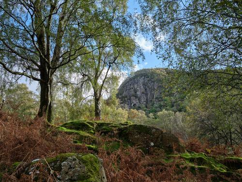
    DSCF4654.jpg

    8. Greatend Crag

    Anyway, onto today's climb and I'd planned to go to the top of this. Fortunately I didn't need to tackle it head on, there's a path that runs up the North edge of it. The summit of Kings How is somewhere up there.

    DSCF4664.jpg

    9. Nurse Log

    I'd heard of these, but never actually seen one before. It's a fallen tree that's ended up providing an ecosystem for seedlings to take root within it. I'm not sure how stable such a thing is, but this one had a fair few healthy looking and sizeable trees sprouting out of it. Presumably their roots will eventually break through the log and find the soil below. Surprisingly, I actually saw another one later in the walk.

    DSCF4689.jpg

    10. Top O'th Path

    The path leading up to Kings How is steep and made of a stone apparently selected for its zero friction property when wet as it was an utter nightmare to climb the damp and slippery steps, so much so that I ended up using my tripod as a makeshift walking pole for extra stability. The climb is about 1,000ft and took me two hours. Partly because of my heart condition meaning I could only manage a few dozen feet of ascent at a time before taking a break, but also because every step needed to be carefully placed and tested before putting weight on it, so that I wouldn't end up on my bum, or worse, my camera! On the way up I encountered the only person I met during the entire walk. A similarly aged chap coming down the steps even more slowly and carefully than I was going up them. At this point I decided I would not be coming back down via this route, apart from the safety aspects, it would have taken too long. Anyway, all that aside, I was relieved to reach the top of the path and turn around to see this delightful view.

    DSCF4719.jpg

    11. Rosthwaite

    Eventually I reached the summit of Kings How and was met with this view looking towards Rosthwaite. In the distance, near the centre can be seen Glaramara, looming behind it on the right is Great End, with Scafell and Scafell Pike hidden even further back. To Great End's right stands Great Gable, head butting the clouds. I summited all of these mountains a few years ago and, with my current health its unlikely I'll ever be able to do that again, but it's good to know I can still reach the top of these smaller peaks and enjoy fantastic views like this. Again, this was framed in camera at 65:24. I also took a less wide view that doesn't include Castle Crag on the right, but in the 3:2 ratio.
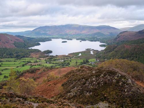
    DSCF4746.jpg

    12. Derwent Water

    Looking North from the summit, you get this view over Derwent Water. The mountain at the far side of the lake is Skiddaw, which I chose as my final fell during my initial round of The Wainwrights a few years back. I doubt the views would be much cop up there today though.

    DSCF4765.jpg

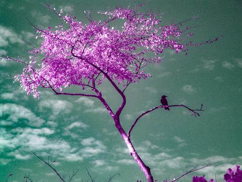
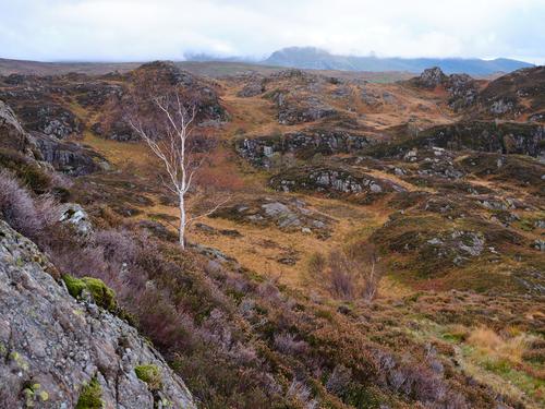
    13. Meanwhile, On Another Planet

    Well, perhaps not. This was taken on the way down from the summit, looking East towards the Helvellyn range. The colour palette is very different compared to the lushness of the Borrowdale valley that it does look a bit like another planet.

    DSCF4766.jpg

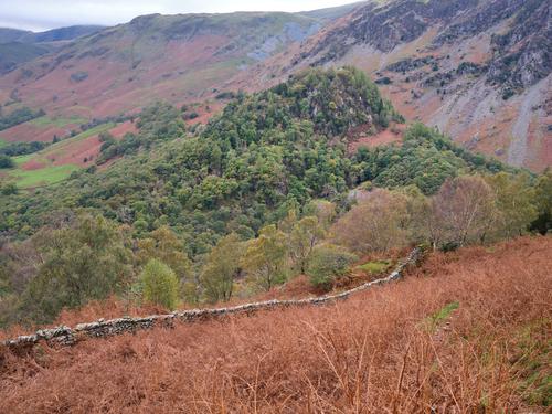
    14. Castle Crag Part Deux

    My route down from Kings How provided this closer view of Castle Crag. I'll have to take a look around those woods at some point if they're accessible. Apparently they are quite ancient.
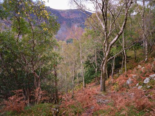
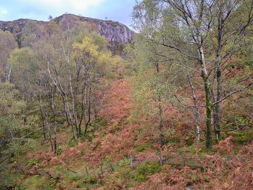
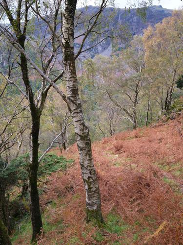
    DSCF4784.jpg

    15. Birches

    This was near the top of the path as it starts to head down the steeper part of the slope. It was still a challenging path to stay upright on, but compared to the route I'd taken up to Kings How it was a piece of cake. One plus point was that it weaved its way through a lovely bit of woods, that I would have really enjoyed if I hadn't been getting exhausted and eager to get back to the car. Maybe next time I'll start at this end?

    DSCF4796.jpg

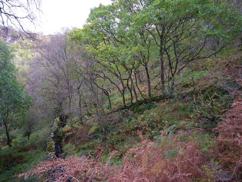
    16. The Woods On The Slope

    By this point I was in the thick of the woods as the path twisted and turned its way down the steep face of Andersonband Crag. Miraculously, I made it down without having an unplanned sit down.

    DSCF4800.jpg

    DSCF4800.jpg

    JPG, 2.0 MB, uploaded by SteveMonks on Oct. 22, 2023.

    DSCF4784.jpg

    JPG, 1.6 MB, uploaded by SteveMonks on Oct. 22, 2023.

    DSCF4796.jpg

    JPG, 1.8 MB, uploaded by SteveMonks on Oct. 22, 2023.

    DSCF4766.jpg

    JPG, 1.4 MB, uploaded by SteveMonks on Oct. 22, 2023.

    DSCF4765.jpg

    JPG, 1.1 MB, uploaded by SteveMonks on Oct. 22, 2023.

    DSCF4664.jpg

    JPG, 2.1 MB, uploaded by SteveMonks on Oct. 22, 2023.

    DSCF4719.jpg

    JPG, 2.1 MB, uploaded by SteveMonks on Oct. 22, 2023.

    DSCF4689.jpg

    JPG, 1.9 MB, uploaded by SteveMonks on Oct. 22, 2023.

    DSCF4632.jpg

    JPG, 2.0 MB, uploaded by SteveMonks on Oct. 22, 2023.

    DSCF4746.jpg

    JPG, 556.5 KB, uploaded by SteveMonks on Oct. 22, 2023.

    DSCF4581.jpg

    JPG, 2.1 MB, uploaded by SteveMonks on Oct. 22, 2023.

    DSCF4610.jpg

    JPG, 1.0 MB, uploaded by SteveMonks on Oct. 22, 2023.

    DSCF4648.jpg

    JPG, 1.5 MB, uploaded by SteveMonks on Oct. 22, 2023.

    DSCF4654.jpg

    JPG, 1.9 MB, uploaded by SteveMonks on Oct. 22, 2023.

    DSCF4623.jpg

    JPG, 838.8 KB, uploaded by SteveMonks on Oct. 22, 2023.

    DSCF4552.jpg

    JPG, 1.4 MB, uploaded by SteveMonks on Oct. 22, 2023.

  • Members 568 posts
    Oct. 22, 2023, 7:03 p.m.

    I like the wide aspect shots, especially the first.

  • Members 1103 posts
    Oct. 22, 2023, 7:32 p.m.

    I admire your stamina. My fave shot.

  • Members 1103 posts
    Oct. 22, 2023, 7:35 p.m.

    Some fantastic shots you have here. Love them All!

  • Members 861 posts
    Oct. 24, 2023, 9:21 p.m.

    dsc00014_$33_72dpi_web.jpg

    Things learned today: some of Sony's cameras only come in Japanese. This 380 kinda feels like shooting with a film camera.

    dsc00014_$33_72dpi_web.jpg

    JPG, 1.5 MB, uploaded by OpenCube on Oct. 24, 2023.

  • Members 806 posts
  • Members 806 posts
    Oct. 25, 2023, 8:40 p.m.

    Another good set, vertical is my pick too :)

  • Members 806 posts
    Oct. 25, 2023, 8:43 p.m.

    The first is my pick but all very good.

  • Members 806 posts
    Oct. 25, 2023, 8:44 p.m.
  • Members 806 posts
    Oct. 25, 2023, 8:47 p.m.

    Creepingly realistic paintings :)

  • Members 796 posts
    Oct. 27, 2023, 10:35 a.m.

    That sounded exhausting with all the climbing up those hills. Especially when carrying all the gear too. I'm not sure if I could do that. How many km was it from start to end?
    Do you also take a note of the total of how many m ascended?
    The reward is all the photos and there's some good ones here.
    My pick would be 3,4,5,6,8,10 &12
    With number 8 from Greatend Crag as the clear winner :-)

  • Members 861 posts
    Oct. 27, 2023, 3:22 p.m.

    "and together we're gonna wait around to die"
    dsc00385_$33_72dpi_web.jpg

  • Members 269 posts
    Oct. 27, 2023, 6:37 p.m.

    I thought you did quite big hikes in proper mountains, not like these little ones we have here in England?

    I record all of my walks with a wrist mounted Garmin Fenix 5X and in most cases record a backup on a Garmin GPSMap, which has a larger antenna, so tends to produce more accurate tracklogs, particularly when under cover such as in woodland, although it doesn't record my heart rate activity, which is something the Fenix does.

    These are relatively short walks, compared to the sort of stuff I used to do before my arteries decided they didn't want to play any more, where I could comfortably manage 14 miles and 4,000ft in a day, probably more, but I never really pushed it beyond that. I can still manage 8 miles in a day as long as it's relatively flat and not too warm, so I can still be reasonably active at this point, but with the medication I'm on it can quickly become very fatiguing, particularly where there's any ascent involved.

    In this instance I measured just short of 4.5 miles and a little over 1,200ft of ascent. The ascent figure sounds about right when compared against my route plan on OS Maps, but apparently the route should only have been about 2.5 miles, so I suspect the tracklog also includes around 2 miles of GPS jitter from when I was in the woods and the Fenix couldn't get a clear view of the constellation.

    The Fenix records all kinds of stats, such as these graphs, which are useful for working out how long specific bits of the walk took and how much my heart was having to work at specific points.

    kings-how-stats2.jpg

    There are also some quite nice summaries, which I tend to find more useful than the graphs.

    kings-how-stats.jpg

    Everything gets automatically backed up to Garmin's cloud service once my phone can connect to the internet, so I don't have to do much in order to manage all of this data, although it would all disappear if Garmin ever decided to stop supporting their service, so I do periodically do bulk backups using some Javascript magic.

    Here's the profile of the route in 3D, taken from the OS Maps website. The route was walked in a clockwise direction and peaks on the top of Kings How. For a bit of scale reference, you can see Castle Crag poking up on this image, just to the right of where the lower part of the route runs.

    kings-how-route-3d.jpg

    It is hard work carrying all of this stuff up even a relatively minor fell such as this one, particularly with the tripod and the two lens setup I'm currently using. The 32-64 and 100-200 together weigh just under 2kg, plus the camera is about 0.9kg and the tripod, despite being carbon fibre is pretty heavy too at over than 2kg including the head, so yeah, I'm looking at a little under 5kg of additional weight. Having said that, I ended up using the tripod as a walking pole for extra stability going up the slippery steps to Kings How, so it didn't turn out to be quite the dead weight I'd imagined it would be.

    For anything more arduous than this I'll be switching back to the Z7, although the lenses I have for that aren't much lighter, but I can handhold that camera in well lit scenarios and still feel like I'm getting my 45MP resolution, whereas, at 100MP on the Fuji I can see a difference between tripod and handheld, even in good light, so it really needs to be on a tripod to make it worthwhile using it over the Nikon.

    kings-how-stats2.jpg

    JPG, 134.2 KB, uploaded by SteveMonks on Oct. 27, 2023.

    kings-how-route-3d.jpg

    JPG, 272.5 KB, uploaded by SteveMonks on Oct. 27, 2023.

    kings-how-stats.jpg

    JPG, 58.2 KB, uploaded by SteveMonks on Oct. 27, 2023.

  • Members 269 posts
    Oct. 27, 2023, 6:46 p.m.

    What great scenery. I really like the colours in these two, making them my picks from this set.

  • Members 269 posts
    Oct. 27, 2023, 6:54 p.m.

    This last shot is the stand out here for me. I like the backlit tree sprouting out of the rock (they end up emerging from the most surprising places at times) and love the gradual depth fade (as we used to call it back when I was writing flight-sims) of the distant mountains.

  • Members 269 posts
    Oct. 27, 2023, 6:59 p.m.

    These are intricate models and you've captured both the character of them and mood of the scene very well. Out of interest, physically how large is this tableaux?

  • Members 796 posts
    Oct. 27, 2023, 7:35 p.m.

    The mountains are higher in Austria, but all the hikes here start from at least 500m and often I'll drive up and start at something like 1200m, or even higher if I can take a cable car.
    In England you'll often start from almost sea level which adds a lot of height to a hike even on a "little" mountain.

    Interesting!
    Looks like you get quite some detailed stats.
    If I'm on a new hike I'll take an outdoor garmin sat nav with me, but if I've hiked the route already several times it usually stays at home to save weight.

    Up 1000m is about the limit for me, but I prefer and usually do easier hikes.
    Tomorrow will be about 500m up then 700m down, but starting at the top of a cable car at 1600m above sea level.
    I guess it will be about 9-10km distance in total.

    The Z7 and 2 lenses and no tripod is heavy enough for me ;-)

  • Members 568 posts
    Oct. 28, 2023, 7:45 a.m.

    Up 1000m is about the limit for me, but I prefer and usually do easier hikes.
    Tomorrow will be about 500m up then 700m down, but starting at the top of a cable car at 1600m above sea level.
    I guess it will be about 9-10km distance in total.

    [/quote]

    My limit is around 1000m too these days, though 6-700m usually makes for a great day. I rarely count the km, but 9-10 sounds about right. The beauty of the part of the alps where we've been the last couple of weeks is that you can drive to 1850-2000m and start from there. The walks I posted this week have been up to about 2500-2600m.