Sorry, fresco.
Aug. 3, 2024
52
-

-
Some lovely delicate patterns in this set, especially the first one.
Reminds me of the bracken on May Hill I saw a few weeks ago.
-

I need a break
-
I prefer this to the similar shot you posted last week.
-
Superb shots.
My fave. -
Great tour. Love the scenery. and colours...
-
Love that one too!
-
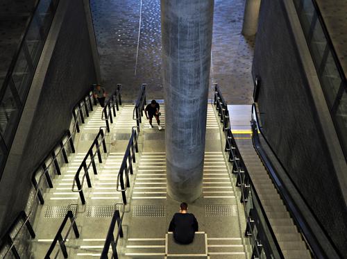
This is a great shot Chris. I Love how that guy has his head 'on' the column.
I kinda wish the other two figures weren't in the shot though. -
Marvel.
-
On The Fells Above Mardale Head
When I visited Small Water Tarn last week, I was weighing up the feasibility of going further with the walk and continuing up the Nan Bield pass to reach the fell tops above. I felt this was still within my abilities, so while I've been off this week to celebrate that I've survived another orbit around the sun I decided to revisit Mardale Head and take another crack at it.
My plan was to follow a circular route, initially heading up to Small Water Tarn before continuing around the tarn and up to the top of the pass. From there, if I felt up to continuing, I'd head for the summit of Mardale Ill Bell and then on to High Street before finally descending via the ridge above Riggindale Crag which would take me past Blea Water, my 2nd tarn of the day.
I wanted to keep things light and the forecast indicated it would be dry all day, so I was going to take the X-T50 and my bag of primes. However, upon weighing the complete package of the X-T50 + 18mm, 23mm, 35mm and 56mm primes, I found it was actually heavier than my Z8 + 24-70 f/2.8S and even adding the 14-30 f/4.0S to the mix still gave me a comparable weight with the big Nikon kit. I do have the Sigma 18-50 f/2.8 for the Fuji which would have resulted in a much lighter kit, but I find the quality of that lens to be somewhat disappointing, so in the end, the Nikon kit was the camera of choice.
All images taken handheld and processed from single raw files in Capture One Pro 23. I think everything was taken with a CPL adjusted for reduced reflections and more saturated looking foliage.
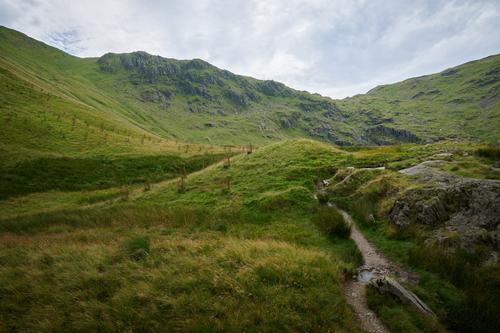
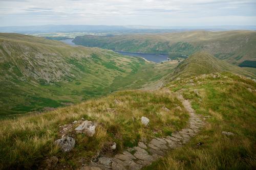
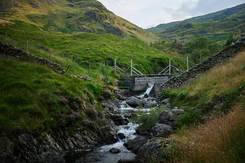
The Rocky Road
Taken early in the hike as I stopped
for a restto admire the scenery and look back at just how far I hadn't come.Small Water Beck
Here I'm stood in the middle of Small Water beck, the stream that emerges from Small Water Tarn higher in the hills.
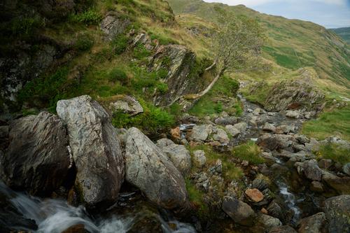
Rocky Rowan
I took a shot of this tree last week and despite having the better camera and a tripod at that time, I completely missed this composition with the three big rocks on the foreground. Still, there's nothing wrong with the Z8, particularly when married to the 24-70 f/2.8S which is a cracking lens and you can still count the leaves on the rowan in the full res version. Eagle eyed viewers might spot the rusty remains of one of the tree guards tucked under the distant rocks on the right.
Phantom Plantation
I've included this because I know how much Woodsider really likes these plantations. I also quite like the way the light is interacting with the grass in the foreground. Woodsider's comments about these things in one of last weeks shots prompted me to rummage through my archives to try and determine just how old this plantation is. It turned out that when I first visited this location back in 2016, they were present then and also entirely missing any contents. Judging by the rusty condition of the guards they've been there quite a long time and whatever they planted simply perished.
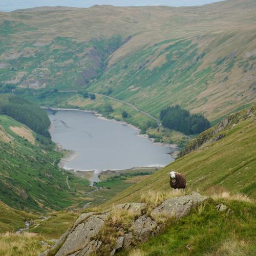
Do You Ever Get The Feeling You're Being Watched?
There are numerous pictures taken as I struggled my way up the steep Nan Bield pass which I've had to omit due to the 16 image limit on a post, also if I'd included everything there'd be about 60 images in this post, but as I approached the top I spotted this 'herdy' watching me from a rocky outcrop with that endearing quizzical look that just comes naturally to this particular breed of sheep. I could have done with a longer lens for this shot, but 70mm is the best I had on me, so I've had to crop this in a bit to stop the sheep getting lost in the scene.
A Glimpse of Kentmere
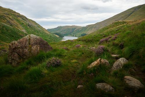
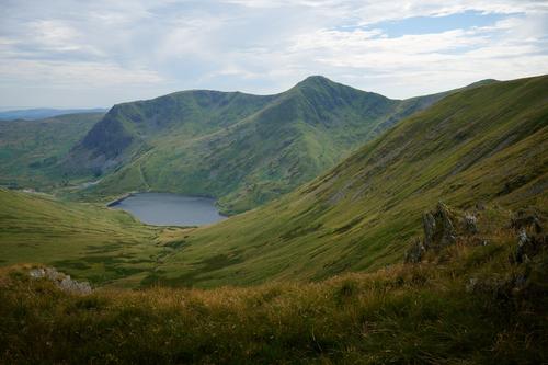
At the top of the Nan Bield pass you have the option of continuing in one of three directions. To your left is the path leading up to the summit of Harter Fell, to your right, the even steeper path that leads to the summit Mardale Ill Bell and straight ahead, the path leading down into Kentmere. Of course, being the master route planner that I am, I was destined to follow the steepest option, but I stopped here for a while to enjoy this glimpse into Kentmere the sight of its three distinctive peaks on the far side, Yoke, Ill Bell and Froswick (the summit of the latter being just visible above the hill in the middle distance).
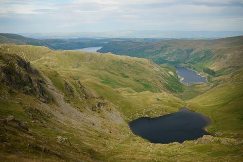
Small Water Tarn
The path to Mardale Ill Bell (not to be confused with Ill Bell in the adjacent valley) is steep and runs along the top of the Small Water crags at one point affording this splendid view of the tarn and the lake it feeds into. The rock I posed on last week is on the right hand corner of that little lump at the top of the tarn where the outlet emerges.
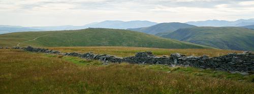
High Street
High Street has quite a history. It has a broad flat top, almost like a field and back in the days when the hamlet of Mardale Green wasn't sleeping with the fishes the local shepherds would hold their periodic 'meets' up here. Apparently horse races were run up here too, although given the treacherous terrain up here that sounds like a great way to break a horse. Going back even further to the days of the Roman occupation and they built and maintained a road across the summit of this fell. I'm unsure if any of that remains today, the only signs of human activity being this gradually deteriorating dry stone wall and a similarly deteriorating concrete trig point marking the summit.
The structure seen on the top of the distant hill at the end of the path is the beacon at Thornthwaite Crag. Having once sheltered there in a blizzard I can attest that it's a rubbish shelter that gives you zero cover from the wind despite its 14ft high construction. The view from there is pretty good though.
Riggindale Crag
I didn't hang around too long on the summit of High Street as it's quite featureless, so it wasn't long before I reached the top of the ridge above Riggindale Crag which would take me back down to Mardale Head. I once found myself at the top of this ridge in a blizzard (there's a pattern emerging here...) having come up from Mardale Head over the top of Harter Fell with the intention of descending here, but this whole path was completely covered in snow so deep you couldn't tell where the path was. Just a bit higher up the ridge behind me is a steep, loose scree section which was also completely concealed by snow on that day. We debated proceeding, but as there are steep drops on either side, we decided it wasn't safe to proceed this way and ended up having to retrace our steps back over High Street and Mardale Ill Bell and instead descend via the Nan Bield pass which was a much safer option.
Having now seen the state of this path (particularly the top section) and descended it in ideal conditions I'm confident we made the right decision in turning back on that day, in fact, I wouldn't be particularly keen on descending here in rain as the polished stones you need to scramble over would get very slippy.
Anyway, on the left here we can see the valley of Riggindale as it appears from the head of the valley, with Haweswater snaking away into the distance.
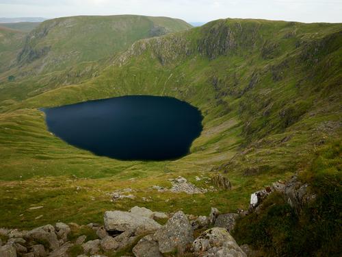
Blea Water
On the right as you descend the ridge lies Blea Tarn, separated from Small Water Tarn by that ridge at the back (and a few hundred feet of altitude). This tarn is much larger than Small Water and is surrounded by steep impenetrable crags and with a depth of 200ft is believed to be the deepest tarn in The Lake District.
Blea Water Outlet
No, not some discount Lakeland retailer, but where water leaves Blea Water to form Blea Tarn Brook. From the look of it, there was once some sort of small hydro electric plant across the outlet, probably to power mining activity in the area, but I can't find any reference on that.
Shadowy Ridge
It was getting quite late by the time I left Blea Water and the shadows were growing long in the scene before me. This is the ridge that separates Small Water Tarn from Blea Water.
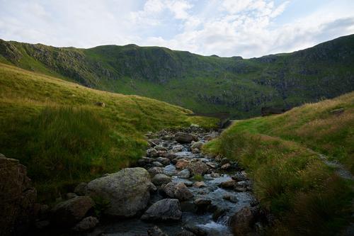
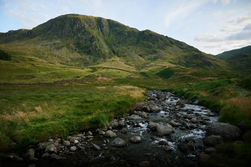
Mardale Beck
Eventually, the waters of Small Water Beck and Blea Water Beck join forces to form Mardale Beck for the final stretch of their journey to meet Haweswater. In this shot of the weir further down the beck you can just see part of Small Water Beck near the top of the frame which is roughly in the area where the rowan picture was taken earlier in the walk.
In The Shadow Of The Fells
A small stone building beneath Harter Fell.
The Last Leg
The final stretch of Mardale Beck as it makes its way towards Haweswater. This was also the last part of the walk for me and by this time I was getting exhausted. It had been a hot day and I'd walked much further than I had for a long time, so the last quarter mile to the car park (which is off to the right) was a struggle.
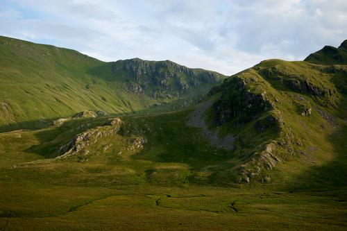
Harter Fell
I think this was taken from the same spot as the previous shot, but looking in the opposite direction towards Harter Fell which was looking magnificent in the last of the light.
It's a funny old thing, but I've never thought much about this fell on the numerous occasions that I've climbed it. The paths are steep and boring, the summit is nondescript, there's really not much going for it, but viewed from the right angle and probably more importantly, far enough away, it's quite a splendid looking mountain.
In this shot, the car park is just off to the left, but it's at the same height as that tree plantation you can just see sneaking into the frame on the top left, making that final trudge to reach the car very unappealing. Having said that, it was a very enjoyable walk and ever so nice to be back up amongst some of the bigger fells.
-
Superb architectural lines.
-
I must admit, I rather like the colour. I should think it works well in the wider landscape around those parts. The fresco work is astounding. This isn't a place I was aware of, but will have to make a detour there on my next visit.
I believe pink is a tradtional colour for plastered walls through a lot of England, most famously Suffolk Pink, but also I think in Gloucestershire and Herefordshire. I see that parts of the cathedral quarter in Gloucester have been restored to their 'historic colour scheme' - pink. www.gloucester.gov.uk/planning-development/conservation-regeneration/cathedral-quarter-high-street-heritage-action-zone/
The colour was originally derived from the colour of the clay soil (famously red in Herefordshire), plus ingredients such as sloe berries and ox blood!Did you find the church at Kilpeck, with its amazing carvings? If not, that's definitely one for your next visit.
-
So many fantastic shots.
This one is my choice... -
The first is a substantial crop, but I think the focus missed slightly too. 😌
-
Looks a great place to explore.
-
That is a nice composition. These sort of craggy/lone tree shots often benefit from some contrasting lighting conditions, but this one works well enough without.
😂 Thanks!
The grasses are beautiful.Late day shadows are nice here.
-
Nice one 😀
My eye keeps being drawn to the figure with the white shoes... I'd be tempted to vapourise him 😉 -

A beautiful use of UWA, carefully placed subject. Nice one.